Skip navigation

Monthly Archives: August 2018

Recap: I (Chris) was on a business trip in Jordan. At the end of the meeting at the Dead Sea Resorts (see post here), many of our colleagues and I joined a tour to see Petra (see posts here and here). While one can spend a whole day in Petra, some of us were tempted by an offer of a desert adventure.

So in the afternoon, we took this side trip to Wadi Rum which was about 2 hours drive from Petra – 5 of us went with our driver in a minivan.

We met our local guide on a desert crossroad, quite literally at a point in the desert where two paved roads traverse, marked by a street sign.

Jordan has no oil (a poor cousin among the middle eastern oil tycoons) but it has rich minerals (potash) which are valuable fertilizers. We saw lone mineral processing plants along the highway and they are connected by these roads and rail lines.

Our local guide was in his early 20’s. He loaded us on the back of his truck which was opened with two low benches.

Then we just went off-road … and entered the desert !

Wadi Rum ( وادي رم‎) also known as The Valley of the Moon (وادي القمر‎) is a valley cut into the sandstone and granite rock in southern Jordan 60 km (37 mi) to the east of Aqaba; it is the largest wadi in Jordan.

We drove on shallow pre-existing tracks at about 30-40 mph (I estimated, as we were sitting in the back whipping about in the wind).

The scale of this little mountain cannot be appreciated until one get closer and start to notice details of its features.

There are many rock-climbing tours on offer, we noticed at the hotel. Given the way the rock face has been eroded, there are many cracks and hollows where a climber can use to ascend.

Wadi Rum is home to the Zalabia Bedouin who have made a success in developing eco-adventure tourism as their main source of income.

Most of these photos were taken while we were clinging onto our seats and handrails on the back of the truck.

The photo below will give you a sense of scale of these rocks.

The desert is not flat and the visible tracks are drivable actually at some speed.

If the truck go off-track here, it could get stuck in the sand. The ride was bumpy at times but it was reasonably safe if you hold onto the guardrail on the truck.

We stopped by a tented village to have some sweet minty tea. While it was an installation for tourists but it was fun. It also commemorates the spot where “Lawrence of Arabia” was filmed. It won 7 awards in 1963. The real T.E. Lawrence who led the Arab revolt against the Ottoman Empire passed through here in 1917-1918.

While we were criss-crossing the desert, we noticed at a distance some high-tech looking structures. Our guide told us that they are modern tents for tourists and the facility is run by his brothers. I would like to bring Sue and sis here for a few exotic days of camping.

By now, how can you not think of Tatooine in the Star War movies where Luke Skywalker was brought up ? (That episode of Star Wars was not made here, however). This desert has been used in numerous sci-fi movie, the more recent ones are Rogue One (Star Wars franchise) and Prometheus (Aliens franchise).

By the way, I was happy to see where/how this aloe-like plant grows natively. Before this trip, I have only seen it in florists around the world as accompaniment to some cactus in little pots. I also saw a Blaps bettle but it crawled away too quickly for me to snap a picture. The desert has many living creatures despite its harsh condition.

Part 2 will have more pictures of the desert as the sun was setting.

I(Chris) had a business meeting at the Dead Sea Resorts area of Jordan. See previous posts.

Amman is the capital of Jordan and is considered to be among the most liberal and westernized Arab cities. It has one of the tallest flag pole in the world. Jordan is a monarchy, having gained its independence in 1946.

Amman is among the most popular locations in the Arab world for multinational corporations to set up their regional offices, alongside Doha and only behind Dubai. When the location of our business meeting was first announced, many of my colleagues were worried about safety. At this time and for quite a long while, there was nothing to worry about really.

Areas of Amman have gained their names from either the hills (Jabal) or the valleys (Wadi).There are approx. 4 million people and it is located in north-central part of the country. Residential buildings are limited to four stories above street level and if possible another four stories below. The buildings are covered with thick white limestone or sandstone.

We spent most of our time at the Amman citadel – Jabal al-Qal’a, (جبل القلعة) – located in the center.

It is probably one of the world’s oldest continuously inhabited places, having been occupied by many great civilizations. Most of the buildings still visible at the site are from the Roman, Byzantine, and Umayyad periods.

From the top, a Roman Theatre built around 100 AD is visible, nested among residential buildings.

Parts of the Temple of Hercules are still standing.

Hand of Hercules. The full status must have been enormous.

While walking about in the citadel, a giant military propeller cargo plane (C-130?) flew above us – reminding us that Jordan is in the middle east.

After the citadel, we had a chance to stroll in the old city, checked out the market and bought some spices.

We walked through a mostly fruits-and-vegetables section of the market.

Fresh almonds, never seen them before until then, they tasted nothing like the dried almonds we eat.

Spice shops. An amazing range of products.

I am so curious as to how they all taste.

And these products are all so inexpensive, except we do not know what they are …  too bad we did not have more time to investigate.

After seeing the famous “Treasury”, we continued with our walk through the gorge which gradually widens and open up to a vast area. I, like many people, thought that the only thing to see in Petra is the Treasury.

It is the highlight of the site but there is an entire city on the other side. Petra (then known as Raqmu) was an important trading post located strategically in the desert at the northern end of the caravan route from Arabia to the Mediterranean. The people had great wealth and power at the time of the first centuries B.C. and A.D. It was reported by the Metropolitan museum of art that the fame of the Nabataean kingdom spread as far as Han-dynasty China, where Petra was known as Li-kan.

Petra is also called the Rose City due to the color of the stone out of which it is carved. Apparently, at certain hour early in the morning, the rock faces are lit by the sun creating a spectacle. It has been a UNESCO World Heritage Site since 1985.

During the reign of King Aretas III (r. 86–62 B.C.), the Nabataean kingdom extended its territory northward and briefly occupied Damascus. The expansion was halted by the arrival of Roman legions under Pompey in 64 B.C. Petra’s importance declined as sea trade routes emerged and many structures were destroyed by an earthquake in the 3rd century.

The Byzantine Era witnessed the construction of several Christian churches, but the city continued to decline, and by the early Islamic era became an abandoned place where only a handful of nomads lived.

It remained unknown to the world until it was “discovered” in 1812 by a Swiss traveller, Johann Ludwig Burckhardt.

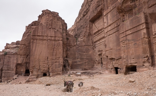
The Nabataeans buried their dead in intricate tombs that were cut out of the mountain sides and the city also had temples, a theater, and following the Roman annexation and later the Byzantine influence, a colonnaded street and churches.

We walked into an amphitheater – one can easily imagine a town meeting or a performance being attended by people who live in the caves around the valley. The theatre consists of three rows of seats separated by passageways and was carved into the mountainside during the reign of King Aretas IV (4 B.C. – 27 A.D.). Jesus was born at around the same time when this was being constructed.

Under the emperor Trajan in 106 A.D., Petra fell to the Romans who annexed and renamed Nabataea to Arabia Petraea. Apart from the many incredible structures carved out of the mountain, they also built free-standing buildings.

Great Temple – remnants

Inside the settlement

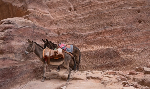
Animals in Petra – donkey – a less active ride than that offered by a camel.

Notice the pattern of marks chiseled in the rock behind the donkeys  !

Looking back towards all the tombs on one side from the Great Temple … one gets a sense of the human scale of this early settlement.

27 sites in Petra are now available on Google Street View. Even if you are not going to see Petra any time soon, it is worth checking it out using better tech than my photos here.

After the business meetings in the Dead Sea Resorts, a group of my colleagues organized a visit to Petra including an overnight stay.

Petra is a historical city in southern Jordan which lies in a basin among the mountains which form the eastern flank of Arabah valley that run from the Dead Sea to the Gulf of Aqaba. It was about 2 hours drive from the Dead Sea.

A little vortex of sand crossing our highway. For us, it was rather dramatic as we entered the sand cloud with zero visibility for a few seconds. Thankfully the road was straight as an arrow.

The picture below was taken from the hotel the night before our visit of Petra which is hidden among these hills.

A visitor center was established to organize visits to the site. One can ride a horse or use a horse-drawn carriage to reach the site which is several kilometers from the entrance. Every one started walking downhill on the Bab al Siq.

Petra is believed to have been settled as early as 9,000 BC, and it was possibly established in the 4th century BC as the capital city of the Nabataean Kingdom.

The Nabataeans were nomadic Arabs who invested in Petra’s proximity to the trade routes by establishing it as a major regional trading hub.

Obelisk tomb carved by the Nabataeans in the 1st century AD.

Above the tomb are four pyramids (‘nafesh’) as well as a niche with a statue in bas-relief that is a symbolic representation of the five people buried there. Below it is the Triclinium, which was a banqueting hall.

The city is accessed through a 1.2 kilometres (0.75 mi) long gorge called the Siq, which leads directly to the Khazneh (Treasury). Two costumed guards stood at the entrance of the Siq (presumably providing employment to the displaced nomads who used to live in the ruins).

The Siq is essentially a rock canal that is 3 to 12 meters in width and reaches up to 80 meters in height. The main part is created by natural rock formation and the rest is carved by the Nabataeans.

Part of the reason the ancient residents survived in the desert is their ability to collect and channel water.

The Siq is gently sloping down towards the Treasury. One can catch glimpses of the Treasury between the rock faces adding to the suspense.

The Treasury is featured in films such as: Indiana Jones and the Last Crusade, and The Mummy Returns. What a surprising sight to see in the desert.

It is amazing that the facade was created by hand-carving into the rock on this cliff face. The scale, labor and workmanship is unbelievable. We unfortunately cannot enter the building/cave.

Apparently, one can visit the site at night where hundreds of candles are lit. It must be magical.

We paid some local kids a little money and were then “guided”(allowed) to climb up the cliff on one side. It was very steep and slippery as the rock is soft and has been worn smooth over the years.

This view gives one a sense of the terrain and the scale of the gorge where this famous sight is located.

Camels were available to transport tourist back to the entrance or to enter further into the site.

In our next post, we will continue with the rest of Petra.