Skip navigation

Monthly Archives: June 2020

Erg Chebbi is a small sea of sand dunes stretching 22 kms long and 5 kms wide and peaking up to 150 metres high. Formed by wind-blown sand, Erg Chebbi is known for its golden-orange sand formations that start at the most northern tip of the Sahara. We arrived at our camp just after 6 pm and were rushed onto our camels’ back for a trip out onto the dune before sunset.

Prior to the trip, I was rather apprehensive about riding a camel for any length of time longer than half an hour. I read somewhere and friends told me that it is an overrated experience, the discomfort far outweighing any fun and novelty aspects. The most common complaints are a sore arse and seasickness.

Luckily for all of us, getting onto the camel was relatively straightforward.  The animals were well-trained, calm and knew what it was supposed to do with minimal fuss. Our guide was very experienced, knowing exactly how to get us posing on camel back in formations for some great pictures.  From left to right, on the camels were SG, IL, IT, Chris, Sue and DL.

After lumbering about for 10-15 minutes, we got off the animals and walked up to the top of a dune which offered a view of the sweeping sea of sand. And it was so eerily quiet.

The sun was below the horizon and the intense orange color was starting to fade out of the boundless sandscape. This was a memorable high point of the trip.

There was not much camel-riding in the end to test the cautionary theories properly. No one complained about any ill effects after the ride.

Having seen the animals up close, I came to appreciate the stoic hardworking camel that serve the nomads for centuries as the only means of transportation across this hostile terrain.

The word “erg” came from the arabic word “arq” meaning a dune field. Erg Chebbi is technically only in an area of semi-arid pre-Saharan steppes and not part of the Sahara desert which lies some distance to the south. And our camp is located at the edge of the sand dune so we were not as “in” the Sahara as we’d like to believe.  But the featureless desert and the rise and fall of the dunes were real and gave us a taste of the Sahara.

By the time we got back to our private tent, dinner was almost ready. While the structure of our tent was formed by a metal frame with layers of fabric, it had a hinged door, an air-conditioner, a shower and a sit-down toilet. What a luxury in the middle of a desert. We were so pampered, and could now claim to have enjoyed the quintessential desert experience, the clueless tourist version.

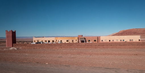
There were a total of 10 tents in this camp. Only two were occupied on the first night, we met the other guests at dinner – a couple from China, and a father and his grown son from Argentina. The tents form a semi-circle with a dining tent at one end. The kitchen, storage and staff quarters were in a small concrete building hidden behind the dining tent.

The dining tent had a high ceiling, silky-plush sofas, spacious table settings, and air-conditioning (not needed).  The food was a better-prepared variation of the tourist menu we had encountered so far.  It was good and we enjoyed it.

Entertainment was provided in the form of traditional songs accompanied by drums and krakebs (a large iron castanet-like instrument). The guy leading with a drum set was also the chef! It was an enthusiastic performance, lasted at least 20 minutes and they seemed to enjoy it as much as we did.

I wondered if they are Tuareg Berbers as most of them wore the indigo-blue djellabas. Tuaregs as a Berber group are semi-nomadic scattered through southern Algeria and Libya, Niger, Mali and Burkina Faso.

A bonfire was lit and we all sat around it to keep warm, and stared at the night sky. We, city-dwellers do not get to see the milky way much and it was mesmerizing and thought-provoking.

Our first night glamping in the desert was quiet and event-less. Slept better than when we were in Fes, in fact.

The following day was another cloudless sunny day. It was then when we had a proper look at the camp (or the resort shall we say). Here is a view of the camp from the dining tent in the morning.

View of the dining tent from the ring of seats around the bonfire.

The format of the served breakfast was similar to an international hotel but with a Moroccan twist – a hot egg-based dish (arrived in a tajine clay pot), several kinds of bread with local honey and jams, pastries, fresh fruits, and unlimited orange juice and coffee. It was scrumptious and plentiful.

Yes, we had had “Tea in the Sahara” – also a 1983 song by The Police, inspired by The Sheltering Sky – a book I was reading on the trip – see our post here.

We saw pigeons around the camp as there was a grove of trees nearby.  But I did not recall seeing any insect.  Apparently many of the desert animals and insects are nocturnal. The evidence of their movements could easily be seen.

We spent two nights at the camp so a full day was available to looking around the area. See later posts.

A group of Chinese tourists arrived during the day and took up all the other tents. Their itinerary was brief – they rode the camels, enjoyed dinner accompanied by the singing and drums, and promptly departed the next morning.

This road trip is one of two which took us across Morocco. We arranged a driver to take us, 6 people, from Fes to Merzouga, south of the country. The journey in a Mercedes minivan started at 7:30 am and covered almost 500 km.

Once we left Fes, we travelled across a plain and approached the Middle Atlas mountain. The Middle Atlas is the northernmost and second highest of three main Atlas Mountain chains of Morocco. In the photo below, the mountain range cast a shadow across the plain as we started ascending in the eastward direction. By the way, the quality of photos in this post is limited by the fact that most were taken from a moving vehicle.

Our first stop was at Ifrane at 1,665 m (5,463 ft).  It seemed that this is a popular tourist rest-stop; several vans (like ours) and tour buses were already parked in front of a cafe.  We got out to stretch our legs and it was surprisingly cold.  We all ordered a hot chocolate in the cafe and stood around a gas fireplace.

Ifrane has a prestigious university –  Al Akhawayn University (saw the signs) – that teaches in English. I found out later that my employer’s local affiliate recruited many of its graduates.

The area enjoys sufficient snow fall during the winter months that it becomes a ski resort – often compared to Switzerland by the locals due to the architecture – chalets with steep roof. It is also popular in the summer for its more temperate climate when compared to that of Fes.

The Middle Atlas is 350 km in length in the north-east of Morocco with a rich biodiversity (in opposed to a barren desert) making it a tourist destination. The region is noted for the endangered primate, Barbary macaque monkey, and cedar forests. Our driver took a short stop to say hello to a small troop of monkeys.

To accompany this trip, let’s have something truly local. Track 3 is good.

We traversed the mountain through an area blanked by a layer of light snow.

We descended on the other side of the Middle Atlas via the Route Nationale N13 highway to face the High Atlas mountain range across a desert plain.

The High Atlas rises in the west at the Atlantic Ocean and stretches in an eastern direction to the Moroccan-Algerian border. The mountain range serves as a weather system barrier running east–west, separating the Sahara from the Mediterranean zone to the north and west. I suspect that while the central plain is in the rain-shadow of the mountain, it gets its water from melting snow.

We took a short break at the small town of Zaida to buy some fruits and masks (DL was rightly worried about the shortage) from the local pharmacy that also sold veterinary drugs (the only time I have entered a drugstore that supplies humans and their animals).

Lunch was taken at Hotel Taddart, a large hotel just outside Midelt, which caters to large tour groups in a caravan of buses. The restaurant felt like a college campus canteen (due to its size) while it offered standard tourist menu at tourist prices. We encountered the largest concentration of Asians tourists here (there were at least 3 full tour bus worth of tourists).

Midelt is the provincial capital situated at 1,500 metres (5,000 ft) in the high plains between the Middle Atlas and High Atlas mountain ranges. It is at about the same elevation as Denver, Colorado, United States – the mile-high city.

Continuing on the highway N13, we crossed the central Moroccan plain and negotiated our passage across the High Atlas at the Gorge du Ziz. The scenery at the Gorge was stunning but we did not manage to take any decent photo to show here.

The River Ziz (Oued Ziz), which flows out of the High Atlas and into Algeria (over 200 km), is important as it irrigates all the agricultural lands south of the High Atlas.

The River Ziz widens at one point to form the Barrage Al-Hassan Addakhil, just outside the town of Errachidia.

Around the junction of N10 and N13, we stopped for snacks and bathroom, and admired the view of the Ziz valley. Where there is water, there are palm trees. If you look for the Ziz river on google map, you will find a green ribbon snaking across a vast expanse of featureless yellow background.

As we approached the oasis town of Erfoud, the terrain became flat and the surroundings started to look like a semi-arid desert. Since leaving Fes, we had passed through at least three biomes.

Erfoud was the filming location of The Mummy, Prince of Persia and Spectre (James Bond), and is best known for fossils. Then, we passed Rissani, the nearest market town to the Erg Chebbi sand dunes – the reason for our visit.

This route is apparently a well-trodden path for those who wants to see the Sahara while visiting Fes. N13 is a single lane highway which ends at Taouz not far further south. We were glad that this trip was not made during the European holiday seasons.

Our destination, Merzouga, is a small village about 35 km (22 mi) southeast of Rissani and only about 50 km (31 mi) from the Algerian border. It is the base for most tourists who are going onto the Erg Chebbi sand dunes.

We reached the end of our day-long ride in the minivan, and were transferred to a 4×4 SUV somewhere on N13, past Merzouga but before Khemliya. As far as we could observe, all the activities in Merzouga and Hassilabied (a village nearby) are associated with tourism, hotels, quad rentals, restaurants, tour operators, etc. I read somewhere, that people call this area a desert theme park.

We transferred into two 4×4 SUV (no 4×4 SUV that can accommodate all six of us) and drove a further 10-15 minutes off-road to get to our destination.  We arrived at our desert camp and were greeted by the staff. It was after 6pm and the sun was setting (hence, the long shadow of our SUV on the ground).

It was almost an 11-hour journey, door to “door”. We were tired but also energized by the change of scenery.

Random moment is our playlist series started during the 2020 pandemic.

Thinking of you – disco

Four songs, Nile Rodgers, old & new, enjoy + like.


#spotify #playlist #nowplaying #chic #daftpunk #sistersledge #roisinmurphy