Skip navigation

Tag Archives: switzerland

Since the beginning of 2023, we have moved our travel blog to a new web site: chrisnsue.com. There you can find new content with better photos, maps and music that will make you feel like you are traveling with us. We invite you to visit our new site and bookmark it for future updates. 

From time to time, we will post here a collection of links to our recent posts that are related to a theme, like a trip or a place, so you can catch up with our adventures. Thank you for your support !

These four posts cover a short trip to Spiez where we used as a base to explore two beautiful lakes, Thunersee and Brienzersee in Bernese Oberland, Switzerland.

Continuing with our story about mountains and …

We woke up at six something and hurried out of the hotel to see the sunrise. Thankfully, the fog had dissipated overnight and the sky above us was clear.

Since Hotel Bellevue was already at the top, it was technically unnecessary to climb higher to see sunrise. But we followed the hotel’s suggestion to get atop of Esel (Donkey) at 2,118 m [6,949 ft] – the second highest point of the entire Pilatus range, just east of our hotel.

It took us about 15 minutes to reach the peak of Esel – we practically ran up the steps as we were a bit worried about missing the moment when the sun appears above the horizon.

Gasping for air which had no moisture at that altitude, we were dying of thirst by the time we reached the top. There were about 10-15 people at the Esel summit which was walled-in and crowned by an iron triangulation cross. The crowd’s sense of anticipation was at a level usually met at a concert performance, and yet sunrise is a daily thing that we all take it for granted.

At 6:56 am, an orange disc emerged from the horizon and rose above the distant mountain ranges. Dawn !

The peaks of the surrounding mountains were first to reflect the warm glow. The view of Lake Lucerne and the city of Lucerne below, visible between gaps in the clouds was spectacular, as was the view southward to the Alps.

There is no word to describe the beauty of the moment and the uplifting of spirit as the rays lit up our faces and the vast expanse above and around us.

Rise and shine. As the sun crept up from the horizon, long sharp shadows were cast across the two hotels and the terrace. We hung around to take pictures and videos along with a small crowd of now excited and satisfied spectators.

On our way down from Esel, we saw a wild mountain goat, also known as an ibex, the kind that is famed for perching on cliffs and jumping off mountainside. It caught us by surprise.

This animal was a baby as its horns were small. In adults, the horns are huge, curved and menacing. Check the photos on the internet. The species was seriously endangered in the Alps until the 1820’s when ibex hunting was banned by the dukes of Savoy in Grand Paradiso (a national park in the Italian Alps). Now they are not so rare in these parts.

Apart from the aerial cable car that we used, there is a second form of transport to get up to Pilatus-Kulm – the cogwheel train. This feat of engineering was commissioned in 1889, having a gradient of up to 48 percent that is the steepest cogwheel railway in the world. From Alpnachstad, it takes about 30 minutes travel time.

Track for cogwheel railway

When we came down from Esel, the first cable car and cogwheel train had not yet started. So we pretty much had the terrace, any sunning chair, telescope and all the viewpoints and trails to ourselves (and a few overnight guests).

I(Chris) decided to explore the “Dragon Trail” which wraps around the mountain behind Hotel Pilatus-Kulm and includes a series of short tunnels cut into a side of the mountain. Windows were created to provide a better vantage point for the view of Lucerne and central Switzerland.

Hotel Bellevue and the aerial cable car terminal from “inside” the Dragon Trail

While it was not cloudy at 2000-plus meter, it would appeared to be a cloudy morning for someone below. We could see a bed of cloud slowly creeping across the woodlands and pastures at lower altitude.

Klimsenhorn Chapel (Klimsenkapelle) at 1,864 m and its crucifix present a set of distant but stunning subjects in the scenery. The neo-Gothic building was inaugurated in 1861 and originally belonged to the Hotel Klimsenhorn, which was demolished in 1967.

The rising sun casted a long shadow behind the chapel.

The chapel remained and is now preserved by a foundation. It was last renovated in 2004. A trail visibly leads up to the crucifix. Just imagine the inspiring, spiritual sight as you walk up to it.

The Dragon Trail afforded different views from the other side of the mountain behind Hotel Pilatus-Kulm. Being the only one on the Trail, I really appreciated the sense of solitude.

Towards the end of the 10-minute walk, the paved Dragon Trail became a series of steps with switchbacks, culminating in a nearly-vertical climb though a hole. A surprising view greeted me as I emerged near the top of Oberhaupt – the other peak that is accessible directly from the terrace.

Oberhaupt (Head-Leader, 2,105 m [6,906 ft]) is located west of Hotel Pilates-Kulm. I was really glad that there were no masses of tourists on the narrow path.

The peak of Oberhaupt is closed to the public due to the communication installations. At that altitude, there were no trees only shrubs.

Hotel Pilatus-Kulm and the terrace and Oberhaupt from Esel

Following a paved path and stairs, I came back down to the terrace next to the hotel, effectively completing a circuit. As there were hardly any one around, it was tempting to do a quick hike on an easy trail to the third and tallest peak – Tomlishorn – which is 20 minutes away.

Instead, I joined Sue for a nice buffet breakfast at the Queen Victoria. After all, with a healthy dose of fresh mountain air, we were very thirsty and hungry by that time.

When we were checking out of the hotel, only a few fluffy clouds remained and the city of Lucerne 1700 meters (5500 feet) below us was visible from our window ! This kind of view of the ground is usually possible only from an airplane.

Click here to see the hotel, cable car and gondola in part 1.

We had a really memorable overnight stay.

On our way back home after a visit to St. Moritz, we used the motorway instead of the mountainous route we previously took.

To see photos of the mountain passes we visited on that route, click here.

Lucerne-Kriens-Pilatus

We stopped at Lucerne for lunch and then sneaked up to Mount Pilatus for the night. Not quite ready to go home.

We were very glad to find that there were spaces in the Parkplatz in front of the gondola station at Kriens, and that it would allow overnight parking.

The first section of the ride from Kriens to Kriensregg and then Fräkmüntegg took about 20 minutes and gained about 900 meters. We were the only ones in the 4-person cabin and had the full 360 degrees-view of the Lake Lucerne area.

The second half of the ride up to Pilatus Kulm was the “Dragon Ride” – an aerial cableway that claims to give a sensation of flying. It is quite new since it was built in 2015. The trip was only about 5-7 minutes and can carry about 50? passengers.

The photos above were taken on the day of our departure. On our ascent, the previous day, the weather was not cooperating (photo below). According to Wikipedia, one of the possible derivations of the name of this mountain is “pileatus,” meaning “capped” or “cloud-topped.”

There are two hotels (50 rooms total) at the mountaintop but we could only book a room in Hotel Bellevue. On arrival, the mountaintop area – Pilatus-Kulm – was obscured by fog. We were seriously concerned that our plan to see sunrise the next morning might be ruined.

All the shops and eateries were closed after the last cable car and cogwheel train departed around 17:45. The hotel room booking included a prix fixe dinner at the only restaurant – Queen Victoria – in the historic Hotel Pilatus-Kulm (which was closed due to off-season or COVID). The two hotels were connected by a terrace and underneath it the concourse for the cable car and cogwheel train.

Throughout the evening, we could roam freely outside on the terrace and stroll indoors to look at the windows of closed shops and some exhibits about the history of the Hotel Pilatus-Kulm. The terrace with empty tables looked quite eerie in the fog.

There were enough guests in the dining hall to not feel like a haunted house. The food was typical continental dishes. The night was made special by the candle lights in the dining hall contrasting the grayish fog visible through the windows.

Luckily, the fog cleared overnight. To see sunrise, we left the hotel at 6:30 am to climb to the top of Esel (2,118 m [6,949 ft]), one of the three peaks accessible from Pilatus Kulm.

View of Hotel Bellevue from Esel, 15 minutes after sunrise

The side of Esel casting a shadow against the rising sun on Hotel Bellevue (photo above).

View of Hotel Pilatus-Kulm from Esel

Queen Victoria rode up the Pilatus on horseback in 1868. Hotel Pilatus-Kulm was built in 1890 and completely renovated in 2010.

See our next post for photos of sunrise at the summit.

Back to Switzerland …  On our way home back from St Moritz, we spent a night at a sheep farm at Alp Flix. 

Click on the link to see our earlier posts on St Moritz, and the nearby Julierpass.

Alp Flix is a protected moorland situated on a plateau of between 1900 and 2000 m altitude, lies within the boundary of Parc Ela – the largest nature park in Switzerland.

The farm Cotti Agricultura is in the hamlet of Tgalucas (top right corner on the map; 1970 m, 6463 feet).  Their web site in German (possibly Swiss German) is here.

To get to the farm, we turned into the village of Sur just after descending from Julierpass on A3. There is a restaurant/hotel, and a church. We saw hunters dressed in camouflage standing next to their truck having a smoke. Wondered what they were hunting.

We continued on the road and started ascending into the low-lying clouds. The paved road became a gravel path lined with two rows of bricks. Conifers lined the road.

After a short climb, we reached the flat plateau which gave us the impression of entering a separate otherworldly realm. The village below was no longer visible, nor were the mountains ahead/above us.

Alp Flix is apparently a popular place for hiking. Cotti Agricultura is not only a farm, it is also a cafe/bar/restaurant, sells home-made milk and cheese, and provides simple accommodation.

The front of the farmhouse has been converted into a reception, a bar and an open kitchen area. When we drove up to the farm and checked in, we were told to park the car at a public parking area about 10 minutes downhill.

Reluctantly, we drove back down to leave the car and walked back. We saw the largest (poisonous) mushroom ever.

It was a nice fresh walk as the drizzle had paused.

Tgalucas

We met the resident shepherd on the kitchen floor – a very smart and alert animal.

The day was grey and misty but it added a lot of mood to the moorland. Cotti Agricultura kept only sheep and we noticed the smallish milking machines. The owner noted that cattle farming requires more land and a much larger scale of operation.

But we did not see any sheep. Perhaps they were all herded up into the mountain to take advantage of the summer pastures, as we were there in early September. We believe they all went up the road that runs alongside a stream behind the farm.

Our dinner (lamb chop, unsurprisingly) was served in a small dining room behind the kitchen. It was spacious for 15 diners. The back of the dining room was a wine “cellar” and behind it, with its own entrance from the outside, the toilets and shower area.

The main reason we chose to stay at Cotti Agricultura was the yurts. They had installed five for guest accommodation. For us, the concept was “camping” in the Alps.

A traditional yurt (from the Turkic languages) or ger (Mongolian) is a portable, round tent covered with skins or pelt and used as a dwelling by several distinct nomadic groups in the steppes of Central Asia.

The yurts are a gimmick and it was popular with visitors. All were booked that evening. No animal pelts were used to make these tents. The white plastic-lined, wood-framed tents were a bit sterile, minimally decorated by a door painted with ethnic motifs.

Next to our yurt, there was a tiny sauna. Nobody used it. For us, we would not enjoy it as, it was rather wet and chilly when you come out. Maybe Scandinavians would like it.

There was no running water or toilet in the yurt. The farmhouse was very close-by so it was not a problem (not for us anyway, since our yurt was the closest to the house).

The yurt felt very roomy inside, except the lack of headroom. We had a circular bed, a couple of stools, and a sideboard. There was a wood-burning fireplace with a chimney sitting on a slab of concrete in the middle of the tent.

There was not a need to use the heater but the risk of carbon monoxide poisoning did cross my mind. No electricity, so we used the provided candles for light. We liked the idea of getting away from modern amenities, like wifi, for just one night. It rained a bit overnight. We slept fine as we must be tired.

Woke up to fresh air, similar foggy grey skies, wet grass. Felt alive and well.

We left after a big breakfast, and rejoined A3 heading towards Albula and then Chur. Our next stop before reaching home was Mount Pilatus near Lucerne.

St. Moritz lies on the southern slopes of the Albula Alps, a mountain range in eastern Switzerland, overlooking the flat and wide glaciated valley of Engadine and Lake St. Moritz.

Because we were visiting just after the peak tourist season, the hotel gave us free unlimited passes for use on the cable cars and funicular trains that were still running, basically all the routes which travel up to the most popular viewpoints.

We traveled up to two other peaks beside Muottas Muragl (see last post): Piz Nair which is directly atop the center of St Mortiz Dorf, and Signal which is situated above St. Moritz Bad.

To reach Piz Nair, a funicular departs from the town center to Corviglia, a ski area at 2,486 m (8,156 ft). Then, we took a cable car to the upper station that is 30 metres (100 ft) below the summit.

Corviglia has a restaurant and a flat area for people to lounge around under the sun, and for young kids to ride their bikes in a small circuit. It is the center of the largest ski area in the Engadine valley.

This mountain hosted the alpine skiing events for the 1948 Winter Olympics. It also hosted the World Championships in 1934, 1974, 2003, and 2017.

From Corviglia, we transferred to a cable car (gondola) to continue our ascent.

There are 24 ski lifts, 36 slopes and 14 mountain restaurants.

In the summer, the same installations support hiking and mountain biking.

As we gained altitude, the conifers thinned out. The biome changed to alpine pasture, and soon the elevation was too high for most vegetation except a thin layer of lichens on rock surfaces.

At the summit stood a statue of an ibex, a large mountain goat with curved horns. Needless to say, the panoramic view from here at 10,026 ft (3,056 m) was fantastic.

Surrounding us were many higher peaks, one with a mini glacier.

We saw many trails radiating from Piz Nair. Several small groups of cyclists were riding with us in the cable cars with their dirt bikes, fully equipped for a fast and furious way downhill.

Signal at 2130 m is another destination that we visited. The cable car station was only 5 minute walk from our hotel in St Moritz Bad.

On the short ride up to Signal, we got to see St. Moritz hugging the lake, from a different direction (west to east).

The trip offered a typical view of off-season ski slopes – almost mundane.

We also saw the funicular that took us up to Corviglia. It did not seem so dramatic when we were on it.

We will end this post with a photo of windsurfing and kite-surfing on Lake Champfer and a corner of the neighboring town of Silvaplana (reaching the limit of our point-and-shoot zoom camera).

To see more above St. Moritz, go to our post on Muottas Muragl, click here.

Muottas Muragl is a location on the southern slopes of Blais da Muottas (2,568 m) and offers at 8,051 feet (2,454 m) the most beautiful vantage point above the lakes of Upper Engadine valley. 

Muottas Muragl is situated between the villages of Samedan and Pontresina, accessible by a funicular railway built in 1907 that takes a 700-meter climb from Punt Muragl.  At the top, there is a hotel and a panoramic restaurant. 

This photo of the hotel and restaurant (with a straight-up funicular) at Muottas Muragl is taken from another mountainous location further down the valley.

We took a bus from our hotel, passed the town center at St. Moritz Dorf then the main train station, heading in the direction of Samedan to the funicular base station (1739 m).

The track is very steep, as much as 54% gradient. There are two counterbalanced carriages that ride on the same track. When the carriages come close together, the track splits into two as a “passing loop” for both carriages to pass one another.

We did not time the ride but it felt like 10-12 minutes. The first half of the line ran entirely through a forest, the second part of the line went on open mountain pasture.

The main attraction of Muottas Muragl is the view of the Upper Engadin valley flanked by views of Piz Palü, and Piz Bernina with Biancograt.  Picturesque defined.

Renovated in 2010, the Romantik Hotel Muottas Muragl is the first “Plus Energy” Hotel anywhere in the Alps, producing more solar energy on an annual average than the hotel itself requires. The excess energy is stored by a geothermal circuit underground. It is also CO2-neutral.

Apparently, the restaurant is not a fast-food style cafeteria typically found at summit locations. It is a gourmet restaurant which serves dinner accompanied by a spectacular sunset view. The funicular train runs until 11pm.

We did not bother to get anything there as it was quite crowded (not safe).

The location provides a bird’s eye view of the entire St. Moritz (above).

Unlike most of the high mountain locations, it does not provide skiing, although there are numerous Alpine hiking trails, snow shoeing trails and a toboggan-run to the station below.

There is a short loop behind the hotel that takes one to several vantage points in different directions and art. The iron sculpture (above) by Curdin Niggli, presented in 2007 to commemorate the 100-year anniversary of the funicular railway, symbolises the crossing of the two railways in the middle (in Romansh “Cruscheda”).

We spotted a few hang gliders.

We encountered a herd of black Hérens cows happily relaxing behind an inconspicuous fence.  They seemed to be free to roam anywhere on the mountain. We think the fence is to prevent them from wandering into the restaurant and hotel.

Along the loop, we saw “Sine sole sileo” – the world’s most precise sundial. In winter, it can also be used as an almost equally precise moondial.  Its unique construction makes it possible to read the time to an accuracy of an incredible 10 seconds.

«Il Guot» – Romansh for «the drop» – is a unique work of art created by Timo Lindner to mark the centenary of the funicular railway. The drop, which is made of natural stone and mortar and coated in white marble, symbolises water in all its various forms, from rain to ice to snow.

It was a really nice sunny windless day with comfortable temperatures. R & R at high altitude.

Dear Readers, Happy 2021 !

What a nightmarish year we had.  Glad that it is the beginning of a new year.  Although the problems are not going away immediately, it is however symbolic that we are all moving on, to a better tomorrow. And we will …

It is a tradition on this blog to take a look back at some of the places we visited last year. Because of the pandemic, we traveled very little, Morocco in January and the Eastern side of Switzerland in September, plus a day trip to Bern.

Marrakesh, Morocco – Jemaa el-Fna and Kotoubia

Dar Darma, Marrakesh

Merzouga – the edge of Sahara

Essaouira on the Atlantic coast of Morocco

Grimselsee at 1,908 m (6,260 ft), Switzerland

Muottas Muragl at 8,051 feet (2,454 m) above St Moritz

A night in a yurt at Tgalucas, Alp Flix at 6,463 feet (1,970 m)

Staring at Piz Bernina 4,049 m (13,283 ft)

A night on the Pilatus summit at 6,801 feet (2,073 m) to see sunrise before 7 am.

Sunrise from Esel at 6,949 feet (2,118 m), Mount Pilatus

Oberhaupt at 6,906 feet (2,105 m), Mount Pilatus

The Parliament Building, Bundesplatz, Bern

For 2021, I(Chris) bought a new camera by Olympus with 2 lenses – the pictures above (and many others on the blog) were taken using a Lumix LX7 or a Lumix TZ101.  The photo below was snapped by an iPhone XR –  it is not from an advertisement. We will have a separate post about the camera system later.

Testing the new camera around town – Lausanne.

We also upgraded our software from Lightroom 6 to Lightroom Classic.

Hope to make more black & white photos in 2021.


On our second day of this road trip to the Eastern side of Switzerland, we drove from Andermatt (after a detour to Airolo and San Gotthard pass) to St. Moritz.

How about a bit of Bach for this stretch of the road trip:

We took Hauptstrassen 19 running alongside the river Vorderrhein (which feeds into the Rhine) to Flims, crossing the canton border from Uri to Graubünden, and passing through a string of picture-perfect villages.

The famous Glacier Express also runs through this valley.  It is 90 years old in 2020 and claims to be the slowest express train in the world. See the avalanche barrier (photo below on the left) protecting the road and the track.

The tourist train with panoramic windows and catering onboard runs a 8-hour journey from Zermatt to St Moritz covering a 290-km length that includes 91 tunnels and 291 viaducts. This train is the best option to see this area without driving.  We might use it to see areas that are not reachable by car in the future.  Highly recommended.

We just caught sight of one going over a bridge above us.

Before the village of Disentis, we passed but did not stop at Oberalpass 6706 feet (2044 m).

This pass is important logistically, and different from the others because not only it has a small lake (Oberalpsee), it also has a train station, a ski area, and a lighthouse!

The 14 m-tall lighthouse was installed in 2010 as a tourist attraction and came from the river Rhine further downstream.

This was a local train which runs between the villages and uses the same viaducts and track as the Glacier Express.

We turned South on A13 towards Thursis but detoured to see Viamala-schlucht (see post here), before continuing to Albula.

Joining the national highway A3 at Albula, we passed Lake Marmorera within the boundary of Parc Ela.

The road became twisty again as we started our ascent towards the fifth mountain pass – Julierpass.  But this road is nowhere near the spectacles of Grimselpass and Furkapass we saw the day before.  Apparently, certain sections of this road were rebuilt in 2009 to reduce the number of serpentine turns.

Julierpass at 7493 feet (2284 m) in the Albula range of the Alps connects the Engadin valley with the rest of Graubünden.

Julierpass lies between Piz Lagrev (10,384 feet, 3165 m) and Piz Julier (11,090 feet; 3380 m), and crosses the watershed / drainage divide between the basins of the Rivers Rhine and Danube.

Historically, the romans built a temple of Jupiter on top of the pass.  There are two buildings now – the red one with lots of windows is the Julier Theatre built by Origen – an organization that maintains the Rhaeto-Romanic cultural heritage.  Rhaeto-Romance is a family of romance languages that include the fourth official language of Switzerland – Romansh.

It is a wooden construction and has multiple terraces inside.  The spectator terraces embrace a central stage which directs the view of the audience outside to the vastness of the landscape during a performance.  According to Origen’s web site, Julie Theatre will “dedicate itself to the world theatre, it will act with the seasons and reinterpret the mountain pass as a place of culture.”

The other building is a tower but we cannot find a description about it. Both buildings were closed and there was no one around except curious motorists.

From this point on, the drive was all downhill to Silvaplana 5,955 ft (1,815 m) and Highway 27 took us to St. Moritz – 5,978 ft (1,822 m).

We arrived at our hotel in St Moritz after 7 pm and concluded the long day of driving with a nice dinner.

In two days, we managed to see Grimselpass, Furkapass, St Gotthard pass, Oberlap pass and Julierpass – watersheds of major rivers of Northern and Southern Europe.  It was mountaineering by car.  Ideally, we would like to have experienced the vast openness, forever-changing cloud formations, and muted colors of the Alpine landscape by hiking.  We are considering this trip as a preview.

Click to see our earlier posts on this road trip, part 1, part 2, and part 3.

On the second day of our road trip to St. Moritz, after St Gotthard Pass (6,909 ft; 2,106 m), we detoured to see the Viamala Gorge (Viamala-schlucht) in the canton of Graubünden. Click the following links to see our whirlwind tour of these Alpine mountain passes Grimselpass, Furkapass and St Gottard pass. The fourth pass will be featured in our next post.

The gorge was first called the “Evil Road” by mule drivers (“Via Mala” in Romansch) as it was a major obstacle on the approach to the Alpine passes of Splügen and San Bernardino.

Viamala lies between the small town of Thusis and Andeer, and had been recognized since Roman times.  The gorge was created by glacial ice and the water of the Upper Rhine (Hinterrhein) carving into the mountain for thousands of years, resulting in steep cliffs as much as 300 meters deep from top to bottom.

Instead of music, try some natural sounds of water.

Various bridges and tunnels were built over the last few hundreds of years to give better access to this part of the Alps.  The first stone bridge was built in the 1400’s followed by two others built in the 1700’s.  For a motorist with a map, it is still quite confusing.  As a motorway (A13) was built in 1967 along the river near the top of the gorge, one has to find the right exit to reach the visitor center below the highway.  Viamala is only open from April 1 to November 1.

In 1903, a set of stairs was built to enable touristic exploration of the gorge.  In 2010’s, a new visitor center was built by local architects near where once a kiosk stood. It is a strange-looking, modern concrete structure, looking more like a military installation.

The building is positioned at the edge of a 60 meter deep cliff and acts as a transition from the road into the gorge. The placement of the walls, the terrace and the stairs follow the topography.

While the structure appears closed towards the road except the narrow horizontal window, the other faces of the building are furnished with large window panes, as high as the room itself, which frame the impressive landscape.

The visitor center has a cafe and a small souvenir shop stocking guide books and even a 1934 Swiss novel about a murder in Viamala (later adapted into a film and TV show).

This canyon is probably one of the narrowest part of the gorge.  A 359-step staircase descends to the canyon center bringing the visitor face-to-face with the lower half of the canyon.

Half way down the stairs, the path crosses over one channel of the narrow canyon and splits into two.

The path that goes upstream leads to another set of descending stairs which bores through the rock and ends at a viewing platform.

Not quite near the bottom of the canyon, we were wondering where the water level will be in spring/early summer when the snow melts.

The sight and sound must be spectacular here with a much larger volume of water coming down from the glaciers and mountains.

The rushing water carried big boulders from somewhere upstream and left the biggest ones stuck between the walls of the channel.  

The water in the channel cascades from one big boulder to the next, and gushes through tight gaps.

Over the years, the water sculpted the sides of the channel which are now smooth and contoured.  These zoomed-in photos do not do justice to the narrowness and depth of the canyon.

The other path that heads downstream follow the channel hugging one side of the canyon.  It felt a bit like a tunnel as the overhanging rock almost touches the other side of the canyon wall.

It was shady and humid inside the canyon. The smooth rock surfaces that are now exposed suggest that they are underwater seasonally depending on the volume of flow.

The smooth rock faces had been washed by running water and therefore cannot hold onto any soil. The upper surfaces are covered by a carpet of mosses.

This passage ends in a small viewing platform overlooking a slightly wider section of the canyon.

There is another parking area further downstream where one can get closer to the water.

But we had to get to St Moritz before dark, so off we went to the last mountain pass.

For the first night of this short trip, we stayed in Andermatt (1437 m).  It is a mountain village in the canton of Uri, and has been the historical center of north-south and east-west traverses of Switzerland.

The village is connected by three Alpine passes: the Oberalp Pass (6,706 ft; 2,044 m.) to the east connecting the Surselva in the canton of Graubünden, the St Gotthard Pass (6,909 ft; 2,106 m.) to the south connecting with the Valle Leventina in canton of Ticino, and the Furka Pass (7,992 ft; 2,436 m.) to the west connecting with the Obergoms in canton of Valais, where we came from the previous day. To the north the steeply descending Schöllenen Gorge links Andermatt with Göschenen (1080m, 3540 ft).

I picked this piece of music (from an old Peter Greenaway film) to accompany us to mountain pass number 3.

It appears that Andermatt is undergoing an ambitious construction program to expand it into a luxury mountain resort.  We stayed at the new Radisson Blu Hotel which is housed in a multi-storey complex that includes luxury apartments (as holiday homes) and a concert hall.  Sue really enjoyed the hotel’s spa and very modern 4-lane stainless steel swimming pool with turn markings.

Driving on the new third Devil’s Bridge (Teufelsbrücke, built 1958) over the river Reuss, we noticed the graphic on the left (see photo below). Dozens of medieval stone arch bridges (also named Devil’s Bridge) in Europe were built with heroic efforts given the challenging conditions like here, where legend has it that the local populace made a bargain with the devil for the bridge in exchange for their souls. An older second bridge built in 1830 is situated underneath it and the first wooden bridge across Schöllenen Gorge was built around 1220.

Our plan on the second day was to drive over to the St Gotthard Pass but we took a wrong turn and descended the Schöllenen Gorge to Göschenen.  Located at the northern end of the Gotthard Road Tunnel and the Gotthard Rail Tunnel lies Göschenen and its railway station. The village grew up around a bridge over the Reuss.  As a result of our unintended detour, we had to joined the A2 motorway and entered the Gotthard Road Tunnel heading South in the direction of Italy.

Our course change was irreversible since we did not notice any place to turn around before entering the tunnel. Fifteen minutes later, we emerged from the tunnel (17 km, 10.5 miles) outside the town of Airolo (see below) in the Canton of Ticino. The tunnel was constructed in 1980 and was the longest in the world at that time. It runs entirely within Switzerland, consists of only one bidirectional tube with two lanes and is notorious for traffic jams. I was glad that traffic was moving smoothly through the tunnel on that day. Unlike the Grand San Bernard tunnel which crosses the Swiss and Italian border further west, this tunnel is apparently free as long as you have paid the annual fee for motorway access (vignette automobile).

To get to the St Gotthard Pass, we drove all the way back up to the top from the southern side of the Alps, using initially the old road – Tremola San Gottardo – which is the longest road monument in Switzerland and like old buildings, it is listed in an inventory of historic roads.

Looking back at Airolo and the Leventina valley.

It is also one of the highest paved roads in Europe. Located on the left side of the Val Tremola mountain, in one stretch over a length of four kilometers it climbs a height of 300 meters in 24 hairpin bends.

Sue was driving (and I was busy photographing everything) – there were just endless twists and turns.  Half way up, we joined the National Road 2, expecting that the now-unimportant road to be less maintained, but it was pristine, looking like when it was first paved in 1951. For more information on this road, click here for the website of History of Airolo.

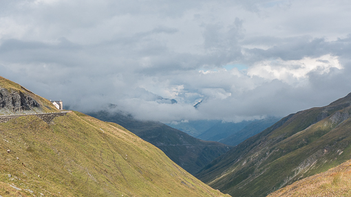
This detour was not planned, but we ended up seeing some spectacular sights on the way down the Schöllenen Gorge and during the climb from Airolo (1,175 m; 3,855 ft) back up to the St Gotthard pass (Passo del San Gottardo) at 2,091 m (6,860 ft).

Once we reached the pass, the view opens up to a high plateau.  There is a cafe/bar (biker’s meeting place), hotel, restaurant, hospice, souvenir shop, museum, historical fortress and several small lakes.

As it was a nice day, the parking area was crowded with cars and a few tour buses, including a Swiss Post Bus.

It was the busiest mountain pass we have seen for the entire trip.  Among the five passes, the quietest was Furkapass (click here to see our previous post).

A chapel dedicated to Saint Gotthard of Hildesheim (960-1038 AD, canonized 1131), who was considered the patron saint of mountain passes, was built on the southern slope of the pass and consecrated by the archbishop of Milan in 1230.  The pass soon became known after the saint, by as early as 1236.  For such a historical place, it was a shame that we did not get to see the Museo Nazionale del San Gottardo (photo below) which was closed for renovation.

The pass is a continental divide between the Rhine, which flows into the North Sea and the river Ticino towards Milan, which after leaving Switzerland flows into the Po and ultimately into the Adriatic Sea.

We saw quite a few wind turbines being installed here, understandably a rather windy place (not on the day we visited).  Some were not fully installed.  What we did not see here was the fortress – Sasso – which required a fee for entrance.  In 1886 the first fortress was built and many secrets surround the buildings which include miles of corridors, elevators, bunkers, and gun stands. Even a hospital lies hidden in the rock.

A set of bronze statutes remind us of the pilgrims, traders, tourists and mountain guides who have been passing through here for more than a thousand years.

We left the St Gottard pass around midday, headed back towards Andermatt, and continued our journey eastward towards the fourth and fifth mountain passes – Oberalpass and Julierpass, before our destination – St Moritz.


Continuing with our road trip (the start of the trip is here) …

Our selection of music to accompany us to the second mountain pass of the day is by Max Richter.

To get to Andermatt where we spent the first night of the road trip, we had to traverse another mountain pass – the Furkapass.  We retraced our drive from Grimselpass back down to Gletsch (1759 m), cross the Rhône in town, and then zigzag up the mountain on the other side towards Hotel Belvedere.

There was a sense of anticipation on this stretch of the drive because Hotel Belvedere which is perched dramatically half-way up the mountain, is visible from all angles. It was particularly eye-catching when you looked up from the Rhône valley on approach to Gletsch.

We parked next to the closed hotel and had our lunch at a snack bar.  When I asked for a hotdog after seeing a photo of a frankfurter, the person behind the counter grunted “no” and noted they only serve the sausage with brown square bread, and not in a roll.  Mustard on the side.  I guess people who live in the harsh mountain environment do not smile much.

I downloaded this picture of the Rhône Glacier in 1900 from Wikipedia (see below). The edge of the glacier was near the Grand Hotel Glacier du Rhône at Gletsch near the base of the valley. We took a picture of the same Grand Hotel (see earlier post here) and the glacier was nowhere in sight now.

In 120 years, the glacier has regressed, presumably due to climate change, upwards to a point where we took these pictures next to Hotel Belvedere.

Water from the glacier collects in a small lake which feeds a stream that runs downhill to Gletsch and beyond as river Rhône.

This is the source of the Rhône (at 2,208 m, 7,244 ft) which empties into Lac Leman (Lake Geneva). In Geneva, the Rhône enters France, continues to Lyon and then southward to Arles, and reaches eventually the Mediterannean. The length of this river is 813 km (505 miles).

A souvenir store was at the end of the parking area of Hotel Belvedere which also serves as the entrance to the Rhône Glacier Ice Grotto (Rhonegletscher Eisgrotte). Only a short walk from the store, the grotto apparently includes a chamber and a 100-meter long tunnel under/inside the glacier which is dug fresh each year. We went to one such ice cave in Chamonix and did not feel the need to see it again. Click here to see our post about that ice cave visit in Chamonix.

Three km up the road from Hotel Belvedere is the Furkapass (2431 m; 7969 feet). The European watershed (continental divide) runs along the pass.  This is one of the snowiest regions in Switzerland.

The road was built initially for strategic military reasons and was the longest pass road in Switzerland when it was opened in 1866.

Once the mountain pass was opened, coaches started services on the route bringing tourists to the area during the heyday of Alpine tourism in the 19th century.

Apparently nowadays, more than 250,000 people cross the pass each year on cycles or motorcycles, in private cars, in Alpine PostBuses or by historic steam train. We stopped at the Grand Tour of Switzerland scenic photo spot.

The Grand Tour of Switzerland is a 1,600 kilometre driving tour through the most beautiful areas of Switzerland, going over five Alpine passes, passing twelve UNESCO World Heritage sites and biospheres and running along 22 lakes.  It is a great site to do research for a road trip in Switzerland (https://grandtour.myswitzerland.com/en/).

Looking down towards the valley from the pass …

This mountain pass became famous after it was used in a car “chase” location in the 1964 James Bond film Goldfinger. One curve on the east side of the pass is even named “James Bond Strasse”.  Here is the James Bond clip on Youtube.

We reached Furkapass and drove down from the east side of the pass to Realp using the same stretch of road as James Bond, towards Andermatt.  The road is just as narrow and curvy as it was shown in the film.  As we descend the Reuss valley, we passed a number of villages with wooden houses and whitewashed churches.

We were using our own car for the trip, so the drive was comfortable as much as it was exhilarating.  All these roads are closed during the winter months and their open/close status can be checked online at Alpinepasse.

Our hotel at Andermatt was a modern luxury high rise but maintained the warm ambiance of a mountain lodge.  We had a quick dinner at the hotel and promptly went to bed, after a long but enjoyable day of driving.

Like millions of people in 2020, due to the pandemic, we worked from home, stayed away from crowded places, and stopped traveling. Before the arrival of winter and the possibility of another extended lockdown period, we decided to go on a short road trip within Switzerland in September.

Driving your own car is safer than public transportation. And we believe it was safer to go up to the mountains as the summer holiday season was winding down. Since we had never been to the sparsely populated, mountainous Eastern part of Switzerland, it was time to explore.  To accompany this online trip, I chose a collaboration by two great musicians.

The easternmost point of this road trip was St. Moritz, the well-known, historical ski resort town in Kanton Graubunden. We took the scenic route from Lausanne via the Swiss Riviera, through the Rhône Valley and start ascending the Alps after Brig.

Starting at 9 am from home, we simply followed A9, mostly a motorway until Sierre. The drive was really easy up to here as this route was built to give quick access to all the major ski resorts in the Swiss Alps, such as Verbier, Crans-Montana and Zermatt.

Our first stop (not scheduled) was at a suspension bridge near Bellwald. It was a surprise discovery as the Hängebrücke appeared on our right after we left A9 to join Route 19. No longer in the French-speaking part of Canton Valais, these parts of Valais use a Germanic dialect.

Many suspension bridges in Switzerland are spectacular and themselves destinations, but they are not easy to reach. This footbridge is built to cross the Rhône River to connect Bellwald (1566 m) on the north bank to Mühlebach (1250 m) at Fürgangen (1188 m, not far from the small train station). Built next to a main road, it has to be the easiest suspension bridge to access for casual tourist like us.

After Oberwald, Route 19 becomes narrower and twisty as we slowly climb alongside the upper reaches of the Rhone River. Then we reached Gletsch where the mountain views become spectacular.

Gletsch at 1,757 m (5,764 ft) is a hamlet located 2.5 km (1.6 mi) below the edge of the Rhône Glacier. It is called Gletsch (derived from Gletscher, glacier in German), since the first building, the predecessor of the Hôtel Glacier du Rhône was built more or less next to the glacier’s mouth in 1830.

The glacier has been retreating from right to left in the above photo, leaving behind the a new section of the Rhône.  Gletsch is just visible at the right edge of the photo below.

Gletsch lies at the crossroads of the Grimsel Pass (leading to the Bernese Oberland) and the Furka Pass (leading to Andermatt where we stayed the first night of this trip).

We drove up to our first pass – the Grimselpass (Passo del Grimsel) at an elevation of 2,164 metres (7,100 ft).

There is a small lake, a cheerful, rusty sculpture, a restaurant and a hotel at the pass.

The pass connects the upper valley of the river Aare, with the upper valley of the Rhône. As the Aare is a tributary of the Rhine, the Grimselpass stradles the continental divide between the North Sea and the Mediterranean Sea.

On the other side from where we came, a paved road runs 38 kilometres (24 mi) from Gletsch to Meiringen. The road is normally closed between October and May, due to the high snowfall on the pass.

Slightly below the pass on the north side are two lakes, Totesee (Lake of the Dead) and Grimselsee. The latter is artificial, created by a dam built in 1932 to generate hydroelectric power (operated by Kraftwerke Oberhasli (KWO) which now uses its local transport network to support tourism).

We descended from the pass to Grimselsee. From a distance, the light-green glacial water was perfectly calm and looked oddly solid.

Across the dam on the other side is a hotel.  One section of the dam allows vehicular traffic.

The hotel – the historic Grimsel Hospiz was our initial choice for lodging for the night, but its 28 rooms were all booked. There is quite a bit of history here – apparently, the first certified guesthouse of Switzerland was located at this exact spot, way back in 1142!  In more recent times, the hotel became a sensation in 1932 as the first exclusively electrically-heated house in Europe (when the dam for hydroelectric power was completed and supplied the power). Really.

Renovated in 2010, the hotel is now open during the summer from June to October and in winter from December to April – “Silent Winter Oasis” – while the pass is closed to driving due to several feet of deep snow, the hotel can be accessed by gondola and tunnels of the KWO power plant. The gondola which traverses a part of the lake was not running unfortunately as the summer tourism seasons just finished (or did not open due to the pandemic).

What a place to spend a quiet cozy Christmas !

Dear Readers,

It has been a tradition on this blog to take a look back at some of the places we visited last year. In Part 1, we posted photos of places we visited in the second half of 2019. Here are the places we visited in the first half.

In reverse chronological order:

Rapperswil on the shore of Lake Zurich

Feusisberg overlooking Lake Zurich, Switzerland, the boats were waiting for the firework on Swiss National Day (August 1) to start after dark

Feusisberg, fireworks from towns around Lake Zurich on Swiss National Day (August 1) – looking in the direction of Zurich – hope it is not too dark online

Place de la liberation, Dijon, France – of course, we visited a mustard factory

Vignoble de Bourgogne (Burgundy) – off D974 between Beaune and Dijon

Rincon Park – San Francisco-Oakland Bay bridge

Powell and O’Farrell, San Francisco

Santa Barbara, view from Belmond El Encanto

Santa Barbara, view from tower at County Courthouse

Lake Cachuma, on the way to St Ynez – lots of rain recently

Heading north out of Los Angeles near Malibu, due to the rain, yellow flowers were blooming

Albertina, Vienna

Hotel Bristol, Vienna

Hlavné námestie, Bratislava, Slovakia

Lenbahhaus, Munich

Munich in January, Frauenkirch (cathedral) visible in a distance

Let’s see where we will go in 2020.

Dear Readers,

It has been a tradition on this blog to take a look back at some of the places we visited last year. In Part 1, we posted photos of places we visited in the second half of 2018. Here are the places we visited in the first half.

Click on the links, where provided to read more about the places of interest. There are usually a series of related posts per location, you can discover them easily in the calendar at the bottom of the post.

In reverse chronological order:

Entrance to Harbor of Lindau, on the shore of Lake Constance in the summer

Red carpet area in St Gallen, Switzerland

Champions League Final in Kiev, Ukraine

Real Madrid scored against Liverpool and went on to win the title 3-1 –  Marcelo, Bale (2 goals – 64′ and 83′), Benzema (1 goal at 51′), Modric and Ronaldo

The Lavra, Kiev (Kyiv), Ukraine

Neues Rathaus at Marienplatz, Munich

Late night Ginza, Tokyo, in April

Zhengyang Gate, Qianmen, Beijing – 正阳门箭楼

Wanchai, Hong Kong in April

WYK, Hong Kong

Wadi Rum, Jordan

Dead sea resort, Jordan

Petra, Jordan

Oslo, Norway where we spent the beginning of the new year

Nobel Peace Center, Oslo

Let’s see where we will go in 2019.

Back in June, we spent one day in St. Gallen, on our way to Kiev from Lindau.

After seeing the Abby and its library (see the post here), we were looking for a place for dinner that was not far from the train station and our hotel. Not really expecting much, Lokal was the restaurant we chose from Google map.

Lokal, which is on the other side of tracks at the train station and it turns out to be a part of The Lokremise.

The Lokremise is a cultural center for St Gallen. It consists of a concert/theater/dance space, an outpost for the Kunstmuseum St. Gallen, the cinema Kinok as well as our bar/restaurant Lokal.

The Lokremise was built between 1903 and 1911 at the time of the textile boom. It is the largest surviving locomotive ring depot in Switzerland.

I wondered what was the purpose of this tower. It looks mysterious.

The depot is a monument of national importance. The buildings were renovated in 2009/2010 and converted into the current complex.

The circular layout of the rail depot has been adapted to form a courtyard for having drinks outdoors.

Some train tracks remain visible under the pebbles. The space can be a really good lounge-y, party space.

Kinok moved into the new Lokremise cube, designed by the Zurich architects Isa Stürm Urs Wolf SA, featuring a cinema room, screening room and bar.

The art museum’s space is situated behind the cinema.

Sculptures and drinks.

The ambiance changed a little after dark.

The post-industrial, high-ceiling dining room is made less grungy by huge mirrors and warm color light fixtures.

Not sure what the idea is with these rows of chrome hemispheres … but they made the large otherwise stark wall a lot more interesting.

The food was overall quite good; the space is phenomenal. Location is super convenient. Highly recommended.


We spent a day in St Gallen, a historic town located in the northeast of Switzerland. It is best known for its university and the Abbey of Saint Gall, a UNESCO World Heritage Site since 1983.

The collection of buildings in the abbey precinct including its magnificent Baroque cathedral form a unique historical ensemble. The appearance of the abbey’s buildings is largely the result of constructions in the 18th century.

The west side includes the Baroque church (the present cathedral), flanked by two towers and the ancient cloister, which today houses the Abbey Library.

The city of St. Gallen grew around the Abbey of St Gall, which is said to have been built at the site of the hermitage of Irish missionary Gallus established in AD 612. The abbey followed the Rule of St. Benedict, which prescribes the contemplative study of literature. 

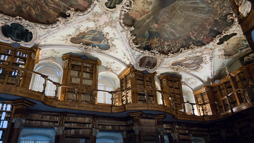
We were in awe of this late baroque Rococo decorations.

The abbey prospered in the 9th century and became a site of pilgrimage and a center of trade, with associated guest houses, stables and other facilities.

As a religious city-states, the abbey joined the Swiss Confederation in 1450s and the town became free from the abbot.

The abbey is an outstanding example of a large Carolingian monastery, represents 1200 years of history of monastic architecture from the Middle Ages.

Confession booths.

The interior of the Cathedral is one of the most important baroque monuments in Switzerland.

Ceiling frescoes.

Scrolling curves, gilding, white and pastel colors, sculpted molding, and trompe l’oeil frescoes – this church has every element of Rococo.

The Abbey library of Saint Gall (Stiftsbibliothek) is recognized as one of the richest medieval libraries in the world. It is also known as the Seelenapotheke (healing place of the soul). It is home to one of the most comprehensive collections of early medieval books in the German-speaking part of Europe.

There was a guided tour and we were required to wear soft overshoes to protect the floor. 

The two-storeys library, its walls and the balconies are ornately decorated. The library hall designed by the architect Peter Thumb in a Rococo style, was constructed between 1758-67. Bookshelves alternate with window recesses on both levels.

The library holds 2,100 manuscripts dating back to the 8th through the 15th centuries which are handwritten, 1,650 incunabula (printed before 1500), and old printed books. 400 of the handwritten books are over 1000 years old. These manuscripts are placed inside the glass cases.

Of particular interest are a beautiful collection of early medieval Irish manuscripts unique in Continental Europe.

The 2,700 year old Egyptian mummy Shepenese is also housed in the library.

This abbey and the library is really THE place to learn and experience central European history and see Rococo.

Closer to home …

Earlier this year while the 2018 Winter Olympics games were being held in South Korea, we went to visit our town’s most famous tourist attraction – the Olympics Museum (Le museé Olympique).

The museum is located on a slope facing Lac Leman, not far from downtown Lausanne. We took a city bus to get there.

The museum houses permanent and temporary exhibits relating to sport and the Olympic movement. With more than 10,000 artifacts, the museum is the largest archive of Olympic Games in the world.

The museum was founded on 23 June 1993, on the initiative of then-president of the IOC Juan Antonio Samaranch.

After 23 months of renovation between 2012 and 2013, the Olympic Museum re-opened on 21 December 2013. Outside the museum is a park filled with sculptures.

The permanent exhibition is organized into three major themes on three separate floors: Olympic World, Olympic Games, and Olympic Spirit. A visit begins on the third floor, where the Olympic World part of the exhibition informs visitors of the history of the ancient Olympic Games and the rebirth of the modern Games in the 19th century.

Highlights include a display of Olympic torches, as well as a video documenting major moments in the history of opening ceremonies history.

The second floor focuses on the Olympic Games.

Mascots from previous games.

Models of stadiums – Bird’s nest from Beijing 2008

Sporting equipment for a variety of sports are on display as well as the more than 1,000 video clips of Olympic Games events and athletes which can be searched and viewed at individual viewing stations.

The uniforms.

On demand are video clips of so many dramatic and magical moments.

The final part of the permanent exhibit covers the Olympic Spirit, where visitors are invited to experience being in an Olympic Village and they can test their balance, agility, and mental skills with interactive exercises.

Interesting optical illusion painted on the ceiling and walls of the stairwell leading down to the Olympic Spirit section.

Olympic medals are also on display. These were from the Winter Games of 1972 from Sapporo, Japan.

We had a lunch buffet which included some Korean dishes while watching the games on the big screen.

There was so much to see. One could spend days here. It was for us a very nice Sunday indeed.

Dear Readers, Happy New Year !

This is our first post of 2018. It is a tradition of this blog to take a look back at some of the places we visited last year. Overall, we traveled less in 2017 than 2016, at least in terms of distance traveled. We did not leave Europe after our Hong Kong trip concluded in January 2017. But we entered the Arctic Circle, visited the capital of Norway, England, France and Portugal.

Click on links, where provided to read more about the places of interest. There are usually a series of related posts per location, you can discover them easily in the calendar at the bottom of the post.

In reverse chronological order:

Oslo, Norway, December-January – Astrup Fearnley Museum

Tromsø, Norway, December – 350 km inside the Arctic Circle

London, December – overnight business trip

Paris, France, December – on the Grande Roue

Lisbon, Portugal – attended a conference at the Champalimaud Centre for the Unknown

Rotterdam, Netherlands, in November – outside the Museum Boijmans Van Beuningen

Lucerne, Switzerland, August – with S&J + family

Panorama from Mount Rigi above Lake Lucene

Verbier, Switzerland in September for business

Aix-les-bains, France in July with friends

Travels in first half of 2017 to come in part 2.


We spent a weekend in Verbier during the summer this year and luckily it coincided with the annual Alps en Fête where we saw the Bataille des Reines, see the post here.

la-marmotte-1

The event was held at the Alpage des Grand-Plans, Les Planards, an alpine pasture above Verbier that was reached by public bus and a minibus operating for the day. The scenery is very much like “The Sound of Music” which is really Austrian.

la-marmotte-15

A road led us up from the bus stop to the pasture where the event was held. The road continues, sloping gently upwards. Along the way, there were two restaurants/lodge. They appear to rent out rooms.

la-marmotte-13

One of the restaurants is called La Marmotte. It was nearly full with people sitting on the outside taking in the sun, breeze and view.

la-marmotte-14

We were lucky to be offered a table with a view under a sun umbrella. After we ordered, we were served a free simple starter – olive paste on crispy bread.

la-marmotte-2

We had a generous portion of tomato soup …

la-marmotte-5

… and assorted mushrooms (mostly girolles and possibly some other kinds) in creamy sauce and a puff pastry. The Swiss likes to gather wild mushrooms.

la-marmotte-7

We also had a beef tartare and fries.

la-marmotte-6

All were excellent. The service was friendly and we had great seats facing the wide open space. Looking up, the nets set up to prevent avalanche and/or falling rocks were clearly visible (not in the photo), as are paths that lead up to the top.

la-marmotte-4

The view here is stunning, blue sky with a few clouds – the entire community of Verbier below –  the pastures on the other side of the valley, fresh air …

la-marmotte-12

Climbing wall for the energetic.

la-marmotte-3

The inside of the restaurant was open but no one wanted to be indoors.

la-marmotte-11

But we can imagine this wooden lodge, now in December with snow falling outside, it must be very cosy. A classic alpine mountain experience (if it is open).

la-marmotte-9

We said we would come back summer or winter.

la-marmotte-10

Highly recommended.

We spent a weekend in Verbier towards the end of July this year. Kind of a last minute thing. Verbier is about a little more than an hour’s drive away.

verbier-1

Verbier is a primarily a ski resort but during the summer, it actively promotes itself as a haven for outdoor sports. Not just hiking and biking though, it also put together a classical music festival.

verbier-3

The music festival is best known for an intimate atmosphere (since it lacks any big venue) and a didactic tradition (masterclasses, student performances).

verbier-2

We were lucky because the weekend we went coincided with the annual village fair. One of the main event took place in the Alpage des Grand-Plans, Les Planards, an open pasture above Verbier.

verbier-6

Apart from a street market in the village, they also held the annual Bataille des Reines (“Battle of the Queens”) – an institution in the local community.

verbier-7

The highlight of the full day event was the Battle – a cow fight. There are no matadors, no enraged bulls and and no stabbing. Humans are not involved here.

verbier-4

This is a tradition that has grown out of letting the cows establish a pecking order.

verbier-8

The cows are sorted according to age and weight before being led into a ring.

verbier-5

The animals were nonchalant around people and standing calmly as a group until provoked.

verbier-13

They appear to ignore each other and eat grass until they decide to get into a bit of a head butting contest.

verbier-11

They were all wearing their cow bells so there were a lot of clanking noise.

verbier-9

We did not see the end because it took them a while to get the cows started and then to separate them. But it was fun.

verbier-10

It was a nice day and we got sunburned because it was not hot or sweaty at that altitude and we did not wear any sunblock.

verbier-12

It is odd to write this post about summer pastures while it is probably snowing up there and knowing that the same place is now all white and rather cold.